
A coral reef is a geological phenomenon as much as an ecological one. One of the first people to appreciate this was Charles Darwin when he ventured throughout the Indo-Pacific. As he explored its many tropical islands, Darwin noticed that the corals did not merely inhabit these islands; the corals helped build them.
A recent study published in the journal Geochemistry, Geophysics, and Geosystems explains how these coral-built underwater structures (known as limestone platforms) help shape undersea landscapes.
A unique and varied seascape
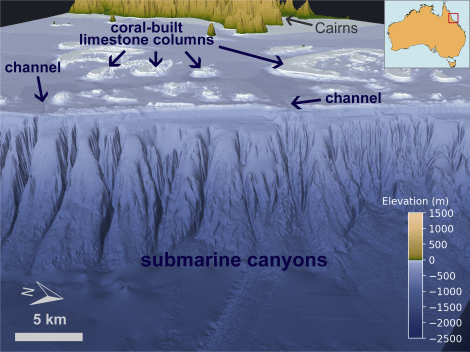
The study focuses on the Great Barrier Reef, which rests off Australia’s northeast coast. Modern seafloor mapping technology reveals a vast framework of limestone platforms – all built by corals. The entire reef structure is so large that it can be seen from space.
Similarly to how trees make tree rings, corals secrete a thin layer of limestone every year. Over long periods of time, these limestone layers eventually rise up from the seabed, becoming tall platforms of reef limestones. Some of these platforms poke out from the sea surface, forming the coral-covered shoals and islands of the Great Barrier Reef that we see today. This platform-building process is a well-known and well-documented ability of corals.
Seafloor maps unveil other standout features that lay scattered amongst the coral-built limestone platforms. Deep channels side-step the platforms, slicing the outer continental shelf. Intricate submarine canyons span the continental slope, their tails stretching more than a kilometre deep. However, unlike the platforms, the processes that form these features are less understood.
High-resolution computer simulations suggest that corals may be the key to shaping not just the islands, but all of these features. To understand how this works, we must revisit the last Ice Age about 20,000 years ago.
Making it rain on the Great Barrier Reef
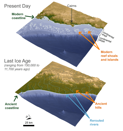
On timescales of thousands of years, the northeast Australian coastline is very dynamic, as the oral histories of Indigenous Australians can attest. During the last Ice Age, colder temperatures caused glaciers and ice sheets to expand, sucking up water from the world’s oceans and draining Australia’s vast continental shelf. At this time, the limestone platforms of the Great Barrier Reef, dry and uncovered, were not islands or submerged shoals; they were hills. Instead of being covered by seawater, these hills were exposed to rivers and rain.
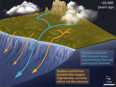
Rain is one of Earth’s great sculptors. On land, rain funnels into powerful rivers that cut into bedrock over geological time, leaving visible scars in the form of channels and valleys. This process can be simulated by computer models, thus establishing a virtual laboratory for understanding the effects of rivers on their landscapes.
Simulations show that instead of being shielded by the ocean, Australia’s continental shelf would have been over-run by rivers and streams. Before reaching the ancient coastline, these rivers and streams would have collided with the exposed hills of the Great Barrier Reef. The hills then re-routed the rivers, concentrating their flow through gaps in the reef structure. In this way, the coral-built platforms encouraged ancient rivers to cut channels on the outer continental shelf. Evidence of this can be seen in modern seafloor maps, seismic sections, and even sediment cores, which yield material deposited by these ancient rivers.
The coral-built platforms also appear to have shaped the numerous submarine canyons that line the continental slope. Once again, simulations suggest that the formation of these canyons was heavily encouraged by coral-built platforms.
During these times of lower sea level, while the platforms were exposed, the canyons would have rested deep underwater, shielded from the cutting action of onshore rivers. However, when rivers meet the sea, the sea does not completely subdue their flow. If rivers are saturated with sediments, these sediments will continue to flow underwater. These oversaturated flows are denser than seawater, causing them to cascade downwards. Like rivers over dry land, these oversaturated flows can also cut into bedrock, even while submerged.
In this recent study, it is argued that the platforms accentuate this process. Because the platforms were very steep, streams would have moved quickly downwards, carrying soils and sediments with them. Simulations suggest that these high-speed, oversaturated streams would have plunged into the steep continental slope, rushing downwards and carving out the canyons.
In his diary aboard the HMS Beagle, Darwin described coral-built islands as “monument[s] raised by myriads of tiny architects.” The true extent of these monuments continues to emerge today. This recent work suggests that the architectural prowess of corals extends far beyond the shallows of the limestone platforms. Through a complex interplay of biophysical feedbacks, these tiny architects help shape the entire submerged landscape, from shallow to deep sea.
Written by Mandi Thran, Jody Webster, and Tristan Salles
Acknowledgements:
High-resolution seafloor imagery was collected and processed through Project 3DGBR. The third map was created using vector graphics provided by the user macrovector, which are available at freepik.com.
